Location of Forts
Within a few weeks after the completion
of the Bluff Fort a number of other and smaller stations had
been planted in the surrounding country. The first of these was
that of John Rains, who went out to what is now Waverly Place,
and selecting a site near a spring built a cabin for himself and
family, and also constructed pens of brush and rails for the
twenty-one cows and seventeen horses brought by him from New
River. Rains is thus entitled to credit for having first
introduced these animals into Middle Tennessee.
George, Jacob and James Freeland and others of the party
selected a site in McGavock's addition to Nashville, and there
beside a large spring which sent forth a lasting stream of
water, built a fort which is known to history as Freeland's
Station. This was connected with the Bluff Fort by a few buffalo
paths running through the thick canebrake which at that time
covered the Sulphur Spring bottom. Eaton's Station was located
on the east side of the river, a mile and a half down the same
from the Bluff. It was built by Amos Eaton, Isaac Lindsey, Louis
Crane, Hayden Wells, Frederick Stump, Sr., Isaac Roundsever,
William Loggins and a man named Winters. This station was
composed of a number of cabins built around a circle with a
stockade from one to another. There were portholes through both
the stockade and the outer walls of the cabins for purposes of
defense.
Kasper Mansker, as previously noted, was by no means a stranger
to the Cumberland country. Now taking with him William Neely,
James Franklin Daniel Frazier and others, he journeyed twelve
miles north of the Bluff to the region of the twin licks he had
discovered while hunting eight years before. Here on the west
side of Mansker's Creek, and three or four hundred yards from
what was later known as Walton's camp ground, they built a fort
which was called Mansker's Station. It was located near
Goodlettsville on the farm now owned by the heirs of Peyton
Roscoe. In the spring of 1783 this fort was moved to a site a
mile above this location on the east side of the creek. Mansker
was of German descent, and in conversation with the settlers
spoke broken English. Though without collegiate education he was
a man of fine intelligence and superior 1 judgment, a great
woodsman, a splendid marksman, a mighty hunter and a brave
soldier. No man among the early pioneers understood better than
did he the art of Indian warfare, and on this account he was
able to render excellent service in routing the savages from the

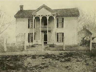
Residence of Mrs. Hattie Utley near Goodlettsville Former Home
of Kasper Mansker
Cumberland Valley. In the early
days he was the proud possessor of a flintlock rifle which he
called "Nancy," after the manner of the old hunters who were
given to the habit of denominating each his favorite weapon by
some feminine nickname. In his later years the younger
generation often listened with eager attention while he related
his exploits and conflicts with the Indians. Soon after the
founding of his station Mansker was made a colonel in the
frontier militia. He engaged actively in nearly all of the
bloody wars which followed, and though far advanced in years was
present at the taking of the Indian village Nickajack, a
campaign to be described later on. His wife, like himself, was
of foreign birth, and lived to an advanced age. To them no
children were born. Both, true to the instincts of their
nationality, were thrifty, and in their old age owned and
occupied a fine farm near the site of the second fort. Here they
died some years after the cessation of Indian hostilities. Their
remains are buried in the family cemetery on the old homestead,
now owned by Mrs. Hattie Utley.
During the spring of 1780 Isaac Bledsoe built a fort in Sumner
County at the lick he had previously discovered. The time of the
location of this fort is positively determined by the fact that
Bledsoe's Station is mentioned in the compact of government
which was formulated at Nashborough on May 1, 1780. The site of
this fort is near Castalian Springs and on land now owned by
Henry Belote. In the walls of a barn belonging to the latter are
some of the old logs used in the construction of the station
cabins.
Another of the immigrants by the name of Asher, taking with him
a party of companions from the Bluff, went twenty-eight miles
northeast into Sumner County and built a fort two and a half
miles southeast of Gallatin on the buffalo path leading from
Mansker's Lick to Bledsoe's. This was called Asher's Station,
and was located on what is now known as the Arch Overton farm
near the dirt road leading from Gallatin to Cairo. .Some time
during the month of January or February, another party
consisting of Thomas Killgore, Moses and Ambrose Mauldon, Samuel
Mason, Josiah Hankins and others went up into the Red River
country and established Killgore's Station in Robertson County
near Cross Plains. Fort Union was also built by Robt. Hays at a
point five or six miles up the river from the bluff and on the
site of the more modern Haysborough.
The settlers at the Bluff and surrounding stations lived during
the first winter and spring chiefly on wild game, which was of
sufficient quantity but very poor in quality. Large numbers of
the deer and other animals of like nature were found to have
died of hunger by reason of the heavy snows and long and intense
cold. All food was of the plainest and simplest of preparation.
The only obtainable substitute for butter and lard was bear's
oil, of which, however, the hunters became very fond. The small
crop of corn raised in the Sulphur Spring bottom the summer
before furnished them a limited supply of bread.

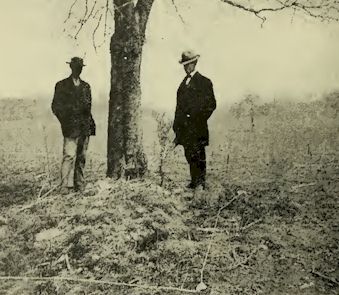
Graves of Kasper Mansker and Wife
In the latter part of January some of
the men in pursuit of game through the woods were surprised to
find traces of a party of Indians. These they were able to
identify by the moccasin prints and also because the toes of the
tracks turned inward, a characteristic of the savage foot.
Following on apace the hunters found them encamped on a branch
of Mill Creek in Davidson County, a few miles south of the
Bluff. The stream mentioned has since been called Indian Creek
because of this incident. The whites returned at once to the
Bluff, and a delegation was sent down from the settlement to
seek an interview, and discover if possible whether the
intruders were only friendly visitors or on mischief bent. The
whites had no interpreter, but after ''heap much talk'' combined
with a variety of sign making it was found that they were of the
Delaware tribe. Probably ignorant of the advent of the settlers
they had journeyed hundreds of miles from their home in New
Jersey for a quiet hunt in the reservation. Having been already
for some time in the Caney Fork country, which at that time
abounded in game, they remained only a few days near the
settlement, after which they quietly took their leave going
south into Alabama. This was the first Indian fright experienced
by the settlers. Many others followed, some of which proved more
serious in consequences.
Soon after the erection of the stations James Robertson, who,
with such marked success, had led the largest of the four bands
through the wilderness, was chosen colonel of the local militia.
This office was conferred by unanimous vote, and for the time
being bestowed the highest authority in matters pertaining to
the government and defense of the settlements. Though several
months had now elapsed since the beginning of the journey from
Watauga, no tidings had yet been received from the river party,
and a feeling of uneasiness as to their safety began to pervade
the colony. Let us return to the scene of their embankment and
follow them through the events of their voyage.
Early History of Middle Tennessee

Early History of Middle Tennessee, BY
Edward Albright, Copyright, 1908, Brandon Printing Company,
Nashville, Tennessee, 1909

|


